From Heretical Hypothesis to Unifying Theory
The concept that solid ground could be in motion, a notion now fundamental to Earth science, was once a revolutionary and widely dismissed idea. In the early 20th century, German meteorologist Alfred Wegener synthesized a compelling body of evidence for his “continental drift” hypothesis. [1][2] He observed the striking complementary shapes of continents, particularly the fit between South America and Africa, and documented geological and fossil records that defied explanation in a static world. [3][4] Fossils of the freshwater reptile Mesosaurus and the land-dwelling Lystrosaurus were found on continents separated by vast oceans, which these creatures could not have crossed. [1][5] Furthermore, evidence of ancient glaciers was found in today’s tropics, while coal deposits, formed in warm climates, were discovered in frigid zones. [1][6] Despite this powerful, multi-disciplinary evidence, Wegener’s theory was rejected by the scientific establishment primarily because he could not propose a plausible physical mechanism capable of moving entire continents through the rigid oceanic crust. [1][6] The paradigm shift occurred in the mid-20th century, driven by technological advances in oceanography. Mapping of the ocean floor revealed a global mid-ocean ridge system, a massive underwater mountain range. This led to the formulation of the seafloor spreading theory, which posited that new oceanic crust is generated at these ridges and pushes older crust aside. [7][8] The definitive proof came from paleomagnetism, the study of the Earth’s magnetic field recorded in rocks. [9][10] Scientists discovered that as magma cools at the ridges, magnetic minerals align with the Earth’s prevailing magnetic field. [8][9] Since the Earth’s magnetic polarity has reversed numerous times, this created a symmetrical pattern of magnetic “stripes” on either side of the ridges, providing a verifiable record of crustal creation and movement. [9][11]
The Gravitational Engine: Unraveling the Driving Forces
The confirmation of seafloor spreading provided the “how” that Wegener’s theory lacked, establishing that the Earth’s lithosphere is fractured into rigid plates that move relative to one another. The primary forces driving this motion are now understood to be gravity-based, far more nuanced than early models of simple mantle convection. [12] While convection currents in the semi-molten asthenosphere beneath the plates do contribute to the overall heat transfer system, the principal drivers are slab pull and ridge push. [13][14] Slab pull is considered the most significant force. [12][13] It occurs at convergent boundaries where a dense oceanic plate collides with and sinks beneath another plate (subduction). As this leading edge of the plate, now a cold and dense “slab,” descends into the hotter, less dense mantle, its immense weight pulls the rest of the plate along with it. [13][15] The speed of tectonic plates strongly correlates with the presence of a subducting slab; plates attached to slabs, like the Pacific Plate, move significantly faster than those that are not, such as the North American Plate. [14] The secondary force, ridge push, is a gravitational effect at divergent boundaries (mid-ocean ridges). [13][16] Here, the upwelling of hot magma creates elevated topography. The newly formed lithosphere is hot, expanded, and buoyant. As it moves away from the ridge, it cools, contracts, and becomes denser, causing it to slide “downhill” from the elevated ridge crest under the force of gravity. [14][15] These two forces, one pulling from the front and one pushing from the back, work in concert to propel the tectonic plates across the planet’s surface at rates of several centimeters per year. [16]
Architectural Consequences: The Landscape of Plate Boundaries
The interactions at the boundaries between tectonic plates are the primary architects of the Earth’s major geological features and the source of most seismic and volcanic activity. [17][18] These boundaries are categorized into three principal types. Divergent boundaries are where plates move apart. [17][19] On the ocean floor, this process forms mid-ocean ridges like the Mid-Atlantic Ridge, where new crust is continuously generated. [17][20] When this rifting occurs within a continent, it creates a continental rift valley. A dramatic real-world example is the East African Rift Valley, where the Somalian Plate is pulling away from the larger Nubian (African) Plate at a rate of a few millimeters per year. [21][22] This process is slowly tearing a section of the continent apart, which will eventually lead to the formation of a new ocean basin. [21][23] Convergent boundaries are zones where plates collide, resulting in crustal destruction or deformation. [17][18] Where a dense oceanic plate meets a lighter continental plate, the oceanic plate subducts, forming a deep-sea trench and a continental volcanic arc, like the Andes Mountains. [18][20] When two continental plates collide, neither can easily subduct due to their buoyancy. [24][25] Instead, the crust buckles and thrusts upwards, creating immense mountain ranges. The ongoing collision between the Indian Plate and the Eurasian Plate, which began around 50 million years ago, is the force that formed and continues to elevate the Himalayas. [24][25] Transform boundaries occur where plates slide horizontally past one another. [17][19] Crust is neither created nor destroyed, but the immense friction generates significant seismic activity. The San Andreas Fault in California is a classic example, marking the boundary where the Pacific Plate grinds northwestward past the North American Plate. [17][26]
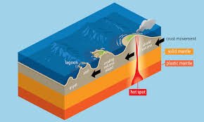
Planetary Cadence: Supercontinent Cycles and Modern Verification
The movement of continents is not random but part of a grand, cyclical process operating over hundreds of millions of years. This is known as the supercontinent cycle, where Earth’s landmasses periodically aggregate into a single or few large continents and then rift apart again. [27][28] The most recent and well-known supercontinent was Pangaea, which formed approximately 335 million years ago and began to break apart around 175 million years ago. [2][27] However, the geologic record points to earlier supercontinents, including Rodinia (formed ~1.1 billion years ago) and Columbia (~1.8 billion years ago), indicating this is a recurring planetary rhythm. [27][28] Scientists predict the continents will reassemble in the distant future, forming a new supercontinent tentatively named Amasia or Pangaea Ultima. [29][30] The theory of plate tectonics has transitioned from inference to directly observable fact thanks to modern space-geodetic technologies. [31][32] The Global Positioning System (GPS) utilizes a network of satellites to measure the precise positions of ground stations cemented into the crust. [31][32] By tracking these positions over years, scientists can calculate the velocity of plate movement with millimeter-level accuracy. [33] Other techniques like Very Long Baseline Interferometry (VLBI), which uses radio telescopes to measure distances between continents by observing distant quasars, and Satellite Laser Ranging (SLR) provide independent verification of these movements. [34][35] These technologies have confirmed that plates are moving at speeds ranging from 2 to 10 cm per year, providing the ultimate validation for the dynamic and ever-changing nature of our planet. [16]